Il contributo meteorologico
 English version
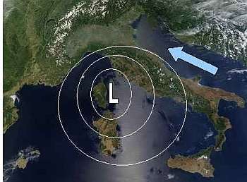
Schema tipo di depressione atmosferica che può causare acqua alta nella Laguna di Venezia (immagine NASA, www.visibleearth.nasa.gov)

Immagine dell'Italia da NASA, www.visibleearth.nesa.gov - Immagine della laguna da C.V.N. www.istitutoveneto.it
Il contributo dovuto al vento può superare anche il metro e provocare da solo fenomeni di inondazione.
La prima figura riporta uno schema ideale di circolazione depressionaria che può provocare il fenomeno dell'acqua alta, mentre nella seconda viene evidenziata la particolare forma del Mare Adriatico.
Anche la bora, che spira da nord-est con intensità spesso superiore allo scirocco, tende ad accumulare acqua verso la laguna, pur se in misura minore a causa del fetch ridotto. Quando alla bora sull'alto Adriatico si associa lo scirocco sul basso e medio Adriatico, si verifica la cosiddetta "scontraura", cioè la convergenza di correnti marine provocate da venti da nord-est e sud-est.
Il fenomeno, noto fin dai tempi antichi, ha fatto registrare numerosi eventi di marea eccezionale.
La pressione atmosferica altera il livello del mare con "effetto barometrico inverso": ad una diminuzione della pressione corrisponde un aumento del livello e viceversa. Di conseguenza, il passaggio di una perturbazione caratterizzata da un'area di bassa pressione sul Nord Adriatico e una di alta al Sud provoca uno spostamento della massa d'acqua verso l'area di pressione più bassa, con una variazione che può arrivare anche a 20 cm.
 Siti meteo consigliati
Meteorological factors and the surges
The regularity of the astronomical tide can be altered, sometimes considerably, by many meteorological factors. Among them, wind and pressure are the most important.
In the case of the Adriatic Sea (a long and narrow basin, closed at the northern end and open at the southern one) a strong wind blowing from South-East (Sirocco) along its longitudinal axis, produces an accumulation of water at the closed end. The phenomenon is favored by the long action zone available to the wind ("fetch") and is further amplified because of the shallow waters in the northern Adriatic.
The set-up induced by the wind can exceed one meter, and it can, by itself, cause flooding in Venice.
First figure shows an ideal scheme of cyclonic circulation that can induce the acqua alta phenomenon, whereas in the second is highlighted the particular shape of the Adriatic Sea.
Also the bora wind, which originates from North-East with an intensity that often exceeds the Sirocco's one, tends to accumulate water into the lagoon, although to a lesser extent due to the reduced fetch. When Bora in the Northern Adriatic is associated with Sirocco on low and middle Adriatic, the so-called "scontraura" (i.e. the collision) is originated, which is the convergence of sea currents caused by winds from North-East and South-East.
The phenomenon, known since ancient times, has led to many events of high tides.
The atmospheric pressure, instead, alters the sea level by the "inverse barometer effect": a decrease of pressure corresponds to an increase in the water level and vice versa. Consequently, the passage of a storm characterized by a low pressure area over Northern Adriatic and a high pressure in the South results in a shift of the mass of water to the area of lower pressure, with a variation that can reach also 20 cm.